Decades after testing atomic bombs many of affected areas are still contaminated. Forensic scientists are tracing that legacy and are finding critical contamination
Originally published on 29. August 2016
Note: This blog entry is based on two articles I published on Spektrum.de and in Süddeutsche Zeitung. I pulled them together here and added a passage mainly because these stories seem unbelievable to day and the old pictures are so interesting. Especially with the photograph above it is well worth following the link.
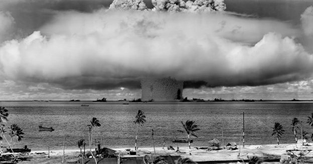
The age of the mushroom clouds began on July 16, 1945, at half past five in the morning. The elite of American physicists had gathered in the desert of New Mexico, about 40 miles southwest of Socorro. It was the first real test of the Manhattan-Project, the first detonation of an atomic bomb. Robert Oppenheimer had designated Trinity as the operation’s codename. The explosive device itself had been given the spoof-name “Gadget”. It was placed inside of a dented cylinder as tall as any of the scientists bearing a mad tangle of cables on the outside. It’s heart were six kilograms of plutonium and it was to achieve an explosive force – or yield in the lingo of the scientists – of 21 Kilotons of TNT.
The physicists had bets running about the impact of the detonation. Most of them underestimated the force they were about to unleash, only Edward Teller’s predicition was overly optimistic. At least that is the way the historian Richard Rhodes describes the circumstances in his book “The Making of the Atomic Bomb”. Now the number the experts’ wager was about has just been confirmed by radiochemists from Los Alamos National Laboratory with a brand new method.
The history of the American nuclear arsenal still generates projects. Scientists look at the legacy of the mushroom-cloud-age. New methods deliver insight into the inner workings of the bombs, and these projects could help monitor future weapons control treaties. Other researchers have fresh data on some of the forgotten locations of the atmospheric bomb tests the US-Army continued to conduct for almost 20 years after the end of World War II – places like Enewetak, Rongelap and Bikini in the Pacific ocean.
This sort of forensic work is necessary because almost an entire human lifespan has passed since the Trinity explosion. So there are at best a few witnesses still alive. Apart from the physicists a lot of young soldiers were at the site and children in other places in New Mexico saw the sudden flash in the sky. Visiting Ground Zero today, which is possible for the general public twice a year, the remains are readily found using Geiger-Mueller-tubes or other such equipment. The numbers they show are ten times as high as in most places of the rest of the United States. But reading details of the “Gadget” literally from the sand – that is a new approach.
The researchers around Susan Hanson of LANL only needed five pieces of glass from the site of the explosion, less than ten grams in all. The intense heat of the test had molten the sand and when the droplets hardened again they enshrined products of the nuclear reactions in the glass. And even though radioactive decay processes have continued in the samples for 70-odd years the scientist can read the type of the bomb and it’s yield from them. All they needed to know was the amount of Plutonium used, readily available in historic records. They calculated the explosion force to be 22,1 kilotons of TNT. That’s identical to earlier results within the uncertainty of the measurements. Now the team looks forward. “Such technologies could expand the timescale for nuclear inspection and data collection”, it concludes, “aiding treaty monitoring and verification endeavors for the foreseeable future.“
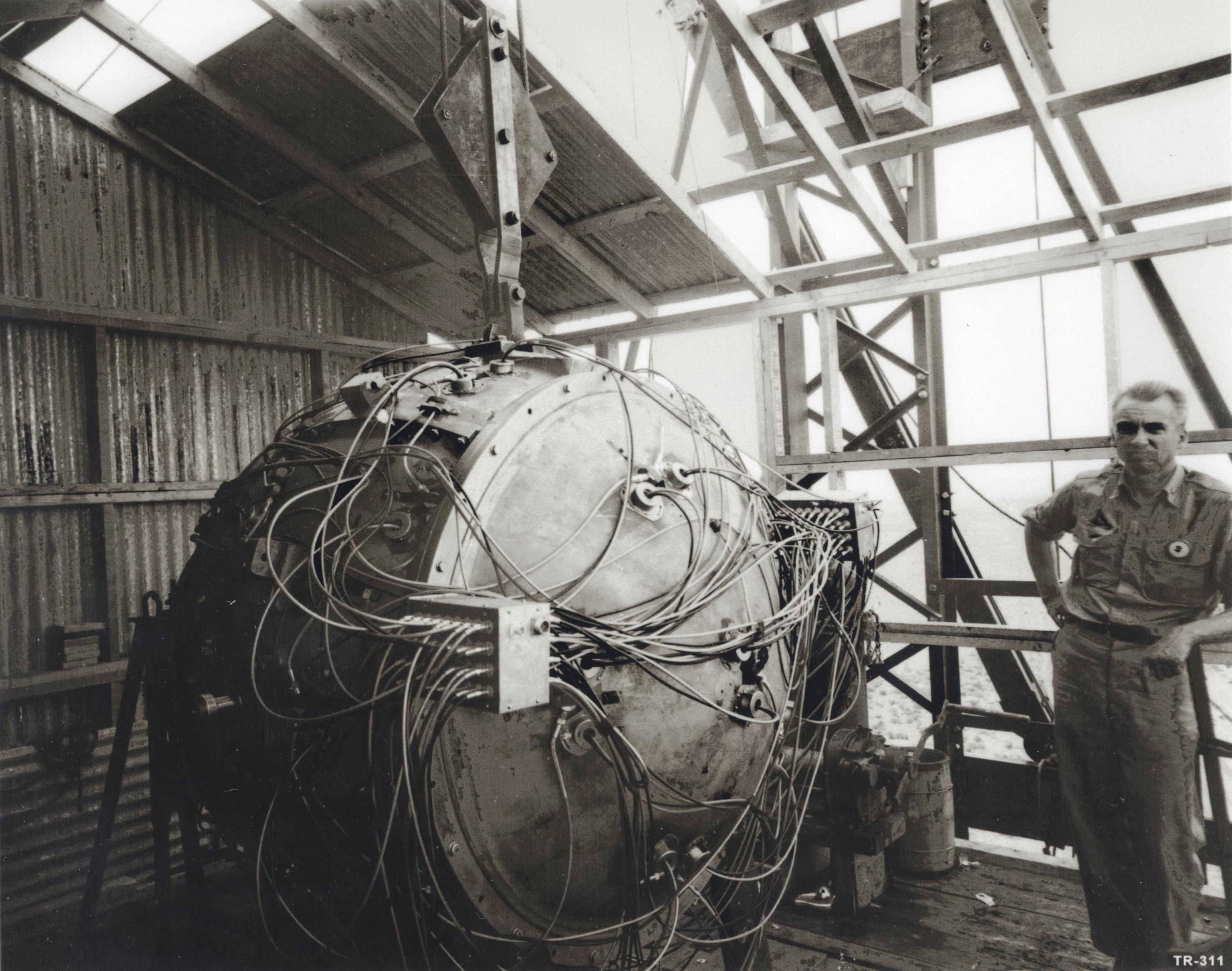
Norris Bradbury, responsible in the Manhattan-Projekt for the construction of the first atomic bomb and the „gadget“, as his creation was called. Source: US-government, flickr
The trick in the case of Trinity was not to look for radioactive remains but for stable atoms, more specifically for isotopes of molybdenum. There nine variants of the element, seven of which are stable. The atomic masses lie between 92 and 100 units. Each isotope has a fixed share of the metal in natural deposits of between 9 and 24 percent. This distribution was warped in the glass samples, however, because the isotopes Mo-95 and Mo-97 are the end points of nuclear decay chains. That means that the plutonium atoms that split in the fireball of the original explosion generated unstable atoms of roughly half their mass which then kept decaying and changing into other atoms until they finally ended up at a stable isotope. So Mo-95 and Mo-97 were getting more plentiful in the glass samples while the same happens only extremely rarely for Mo-96. The decay chain in its direction usually stops earlier.
Looking at ratios of different molybdenum isotopes, namely Mo-95/Mo-96 and Mo-97/Mo-96 the Hanson team was able to see how the explosion had proceeded. The only other thing they needed was the number of remaining plutonium atoms to calculate the number individual fission events and thus the yield of the bomb.
Within four weeks of that first test in New Mexico the Americans dropped two bombs on the Japanese towns of Hiroshima and Nagasaki. After that there followed dozens of further tests – for security purposes conducted not on their US-territory but on atolls far away in the Pacific. Decades have passed since the atmospheric tests were stopped but many of the islands are still contaminated. Time on them is not measured by the metrics of man but by the half-lives of the most dangerous of the remaining reaction products: Cesium-137. It takes 30 years to halve it’s mass.
Officials seem to have been ignorant of how much radiation is left until finally the group of Autumn Bordner from Columbia University went and looked. The researchers just chartered a boat in the summer of 2015 and sailed to six of the islands during two weeks of August.
What they found was that at least Enewetak was relatively safe – at least the main island of the atoll by the same name, which is already inhabitated again by almost 1000 people. The scientists measured dosage rates1 of 0.04 to 0.17 millisievert per year (mSv/y) that affect the islanders from the outside: from ground, water and plants. The median amount was 0.08. The instruments recorded much more in only one spot at the southernmost point: here they read 0.4 mSv/y. All of those numbers at face value are below the limits the United States and the Marshall Islands have agreed on which is one mSv/y. It is taken as a decision tool on whether former inhabitants or their descendents can return. The same limit is used in many industrial countries for the allowable additional radiation from technical sources.
However, measurements like the ones the Columbia team did should not result in more than 10 or 15 percent of the limit. The environment is only one source of radiation, if people also consume local food and drink water that might have radioactivity in them. That condition at least was met for the most parts of Eniwetok: environmental radiation comes up to about eight percent of the limit here. The exposure thus is comparable to what is found on the Majuro atoll that was hardly contaminated during the tests. This is where the capitol of the Marshall Islands is and where many of its residents live in mostly cramped confines.
The all-clear does not apply to the infamous Rongelap, however. It still suffers from the nuclear history. The island was hit by a fallout cloud after the “Castle Bravo” test of 1954. The 64 inhabitants had not been evacuated by the US-Army but then bomb and wind behaved differently than expected. Radioactive ash rained on the island, children rubbed the stuff into their hair, it penetrated every hut and poisoned the cisterns. Many inhabitant developed acute radiation sickness, several died of it even though the Americans soon took all the islanders away.
But they were all returned in 1957 already and the authorities insisted until 1982 that the island was safe even though cancer struck many of the people. Still the islanders were not resettled until Greenpeace sent it’s boat “Rainbow Warrior” in 1985 and took the entire population of Rongelap to a neighboring atoll. A controversial program to clean up the island started with the result that in 1994 the National Research Council suggested upon their return the islanders should only collect food in the southern portion of the atoll. So far the Marshallese people have not taken up that suggestion and have stayed away.
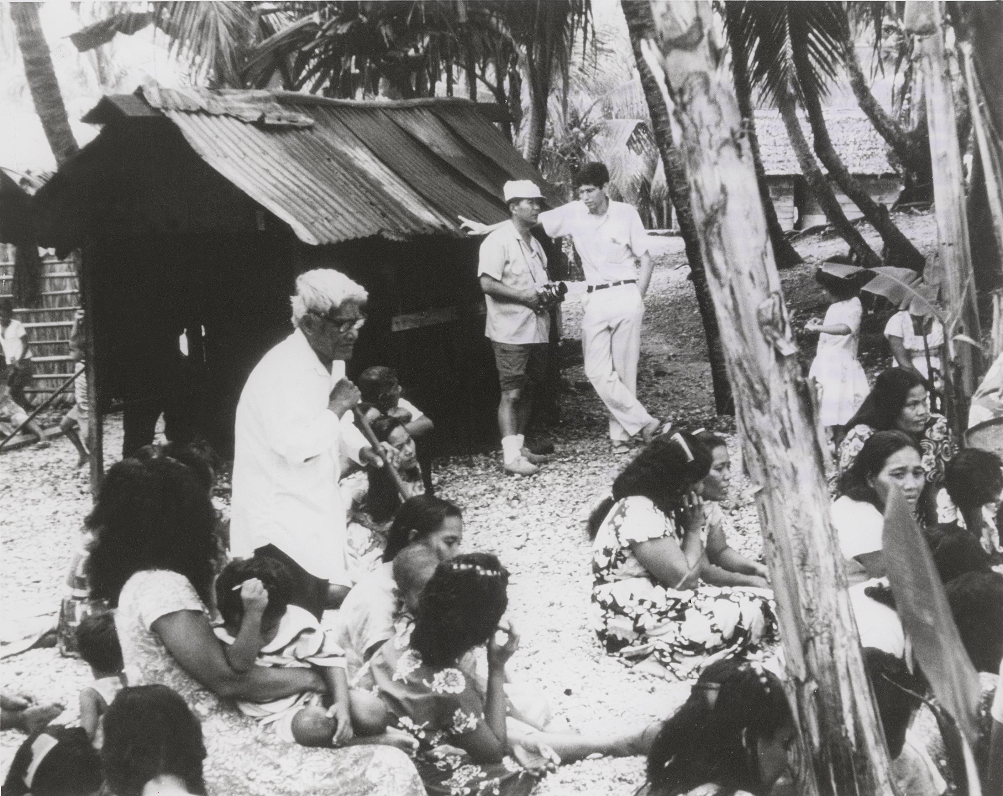 Ten years after the last tests, in the early 1970s, some inhabitants of Bikini were allowed to return to their islands. But the radiation was still – as it is today – so heavy the people had to be evacuated again soon after. Source: Energy.gov, flickr
That seems to have been a wise decision the measurements of the Columbia team show. The scientists found dosage rates of 0.06 to 0.55 mSv/y; the median value was 0.2. Many parts of the island still have too much radiation if the returnees wanted to feed themselves with fish and local fruit. And the numbers on Bikini were even worse. Here the median value was already 1.8 mSv/y, almost twice the limit. Some measurements showed values of 6.5 mSv/y.
On both of the latter islands the possible exposure of people was underestimated severely. The established numbers had been calculated from measurements that were 20 years old in part. And they depended on assumptions of how much time people would spend in their huts versus in the open air. There is no comment to be had about the older methods from Autumn Border and her colleagues. They only state dryly: “Our findings represent a disagreement with [the] projections based on past measurements.” Even history that develops according to seemingly simple laws of physics seems to need an update now and then.
Another uninhabited island the scientists landed on was Runit which also belongs to the Enewetak atoll. This is the place were the Americans pushed radioactive remains of their bombs into a crater left by one of the explosions and topped the landfill with a thin cover of concrete. It contains mainly plutonium-239 which emits alpha radiation easily blocked by any material in its path. Bordner and colleagues didn’t bring equipment for that only for the more penetrating and pervasive gamma radiation. And there was still plenty of that. Right next to bunker the instruments read 0.4 mSv/y. But the limited data they have are far from representative, the scientist warn. They didn’t scan the whole island, presumably with their own security in mind.
Runit is “America’s forgotten nuclear waste dump”, says Michael Gerrard, professor of environmental law at Columbia University. There are no warning signs, let alone security guards on Runit, he noticed when he went to the island in 2010. Many refuse items had just been pushed into the lagoon, others thrown into the crater packed in plastic bags. Among those is the debris of a nuclear dud (just the conventional explosives went off). Most of the crater is below sea level and the “bedrock” it’s formed of consists of coral. The superpower has refused to do proper clean-up and its parliament voted down financial compensation for the locals which had been firmly agreed upon, Gerrard notes bitterly.
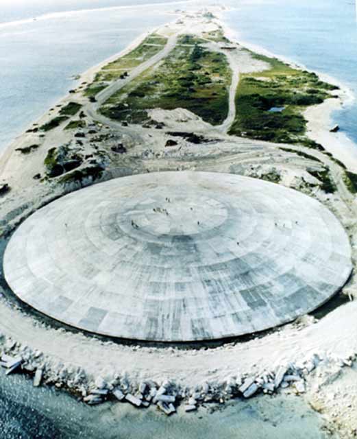
The „Cactus Dome“, named after the bomb test that left a hundred meter crater in the island of Runit, covers a large amount of highly radioactive waste. Source: US Defense Special Weapons Agency/Wikipedia, public domain
Some day the problem will not be confined to a far-away island anymore, however – as soon as it sinks into the Pacific because climate change makes the sea levels rise further. And that’s a fate Runit shares with Camp Century. Judging from first appearances there is little the two places moght have in common. The former is a tropical island that could be idyllic, the latter a stretch of featureless ice in the far north of Greenland. In the Pacific the water could come to the nuclear remains, in the Arctic the remains could come to the water.
Camp Century was a base the US-Army erected in 1959 eight meters below the ice surface (there is a newsreel-type movie about it that obviously was only released decades later). Up to 200 soldiers were stationed there, they tried to figure out whether tunnels under the ice could house mid-range rockets with nuclear war heads. In the end those weapons obviously were never transferred there because the ice showed itself less stable than anticipated within a few years’ time. When the army gave up its “project iceworm” and abandoned the base in 1964, it left behind 200 000 liters of Diesel fuel, 24 million liters of wastewater and a considerable amount of chemical waste. Although the soldiers removed the nuclear reactor that had produced electricity and heat for the outpost, they left the contaminated coolant in a hole in the ice.
 In the beginning the workers were still optimistic their tunnels in Camp Century would withstand the forces in the ice …
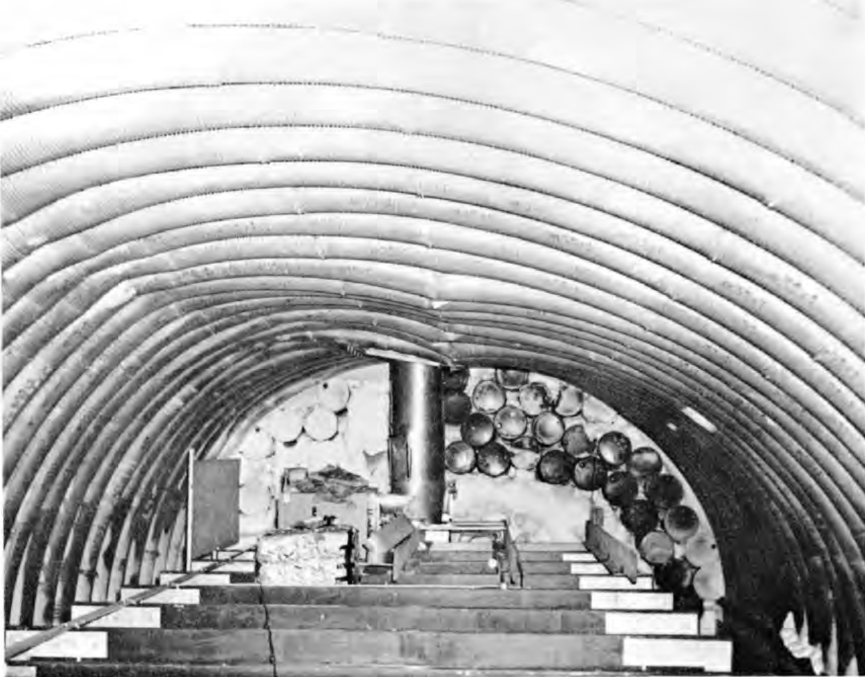 … but soon the loads damaged the metal support beams call „wonderarch“ beyond repair. This picture shows a cavern belonging to the nuclear reactor facility powering the base. Source: US-Army, Technical Report 174 dated 1965
At the moment those toxic remains of the Cold War keep sinking further into the ice sheet. But the end of that process is in sight. “The question isn’t anymore whether but when the pollutants will come to the surface”, sagt Dirk van As of the Danish Geological Service in Copenhagen. Climate Change could reverse conditions in the north of Greenland until the end of this century, meaning the remains of the former US-base could surface from 2120 on.
Van As and colleagues from the US, Canada and Switzerland have reopened a chapter of the American atomic bomb history that was almost forgotten. What they are exposing sounds almost like an alternative ending for the novel “Miss Smilla’s Feeling for Snow”. The scientist have studied documents about Camp Century that have recently been declassified. “The authorities back then were convinced that the ice would never move and that the waste would remain locked away until eternity”, van As says. “But now we know that the ice sheet is moving dynamically.”
Because the documents leave out lots of details the team can only speculate the abandoned base contains “non-trivial” amount of PCB (Polychlorinated Biphenyl). The carcinogenic substance was used as anti-freeze, paint from the time contained up to five percent PCB. The containers that held the paint as well as the diesel-tanks must have been squashed by the ice quite some time ago. The content would still be liquid and enclosed in bubbles in the ice sheet.
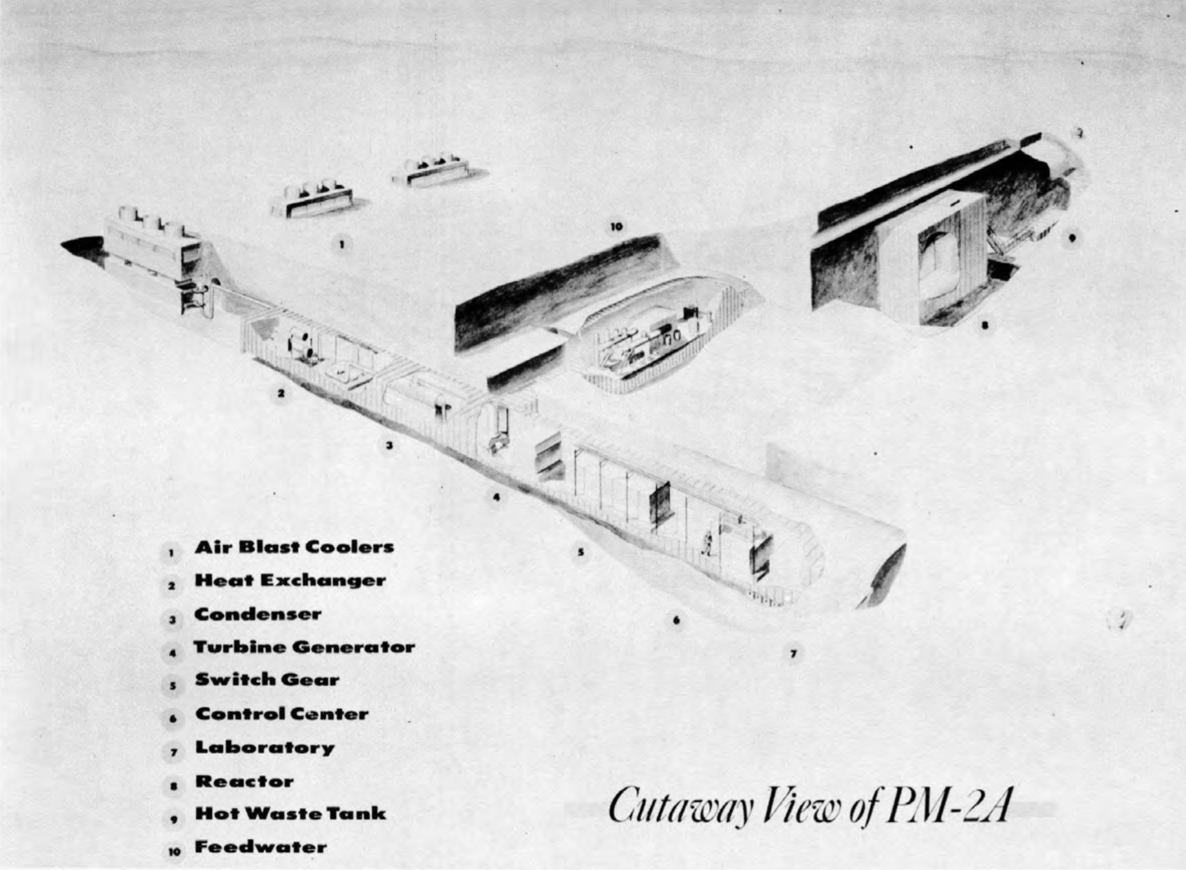 A sketch shows the design of the nuclear reactor with auxiliary rooms which the US-Army installed in the ice tunnels of Camp Century. Source: US-Army, Technical Report 174
That is also where the liquid waste is which the base personnel deposited in holes they made. Those underground chambers, originally 40 meters deep must now lie about 65 meters below the surface because snowfall has been accumulating on top of the former base. That process might continue for some decades, climate models say. One simulation puts the end of the growth after 2100, another sees it reverse around 2090. Some decades after that cracks and rifts could reach the remains and mobilize the contents of the caverns if climate change continues to progress as it has. If the world manages to limit global warming according to the Paris agreement it would slow but not stop the release of the toxic contents of Camp Century.
The scientists know they lack lots of details. “We wanted to go there and make measurements but couldn’t get any funds”, Dirk van As says. Several times financing agencies hinted that the topic was politically charged. One of the organizations the researchers approached to ask for money way the military alliance Nato. After some positive scientific reviews, however, at least one country must have vetoed the project. Van As’s colleague William Colgan of the University of Toronto told the same story in Science. And when journalists then asked the American and Danish governments about Camp Century their questions went unanswered. “Maybe it will get easier after the study and the reports in the media”, van As says. “What we really need to do is make some radar measurements on the ice to know what is where.”
- The paper gives dosage rates in millirem per year which is a measure of the biological effect of radiation on the human organism. The corresponding SI-unit is sievert or millisievert where 100 mrem equal 1 mSv. ↩︎